February 3-10th (2025)
Weather influence on fuels... - Many locations in western Kansas are approaching 80 days without a wetting rain. As a result, ERCs continue to slowly climb despite the lack of fire weather risk. ERCs are in the 50-70th percentile for this region through the period with aggressive fire behavior even under marginal fire weather conditions. Suppression difficulty will increase with any uptick in wind. Further east, recent moisture still remains a mitigating factor for fire weather concerns. Sun angle is gradually increasing along with daylength. This will allow for slightly longer burn periods each week with an increase in drying potential through periods of warm/sunny conditions.
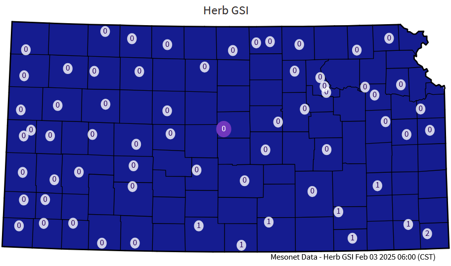
Growing Season Index (2/3/25)
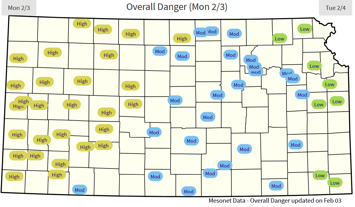
Monday (3rd) - Strong cold front will end the above normal temperatures this afternoon. Winds will shift northerly with gusts to 30mph and higher this afternoon, pushing south through the afternoon. The cooler post-frontal air mass will have moderated humidity in the 40% range, thus, no fire weather concerns are expected.
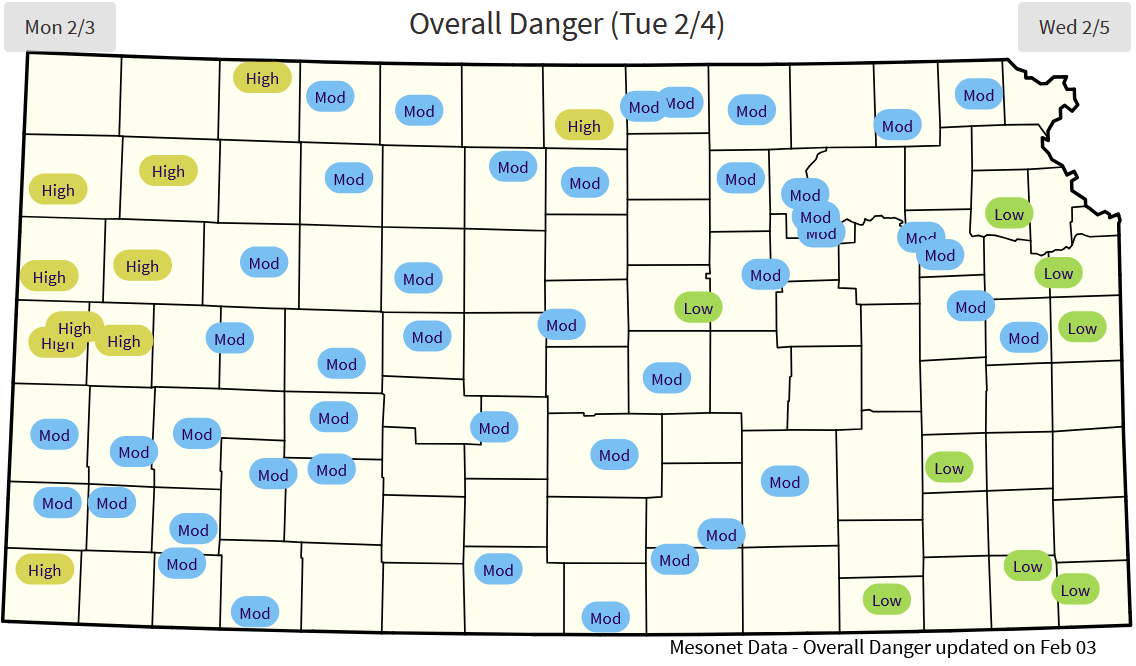
Tuesday (4th) - Easterly flow combined with persistent high clouds will keep humidity up, in the 40-50% range statewide. This will also keep temperatures in the 30s. Winds will be breezy, reaching the 25mph range. No fire weather concerns.
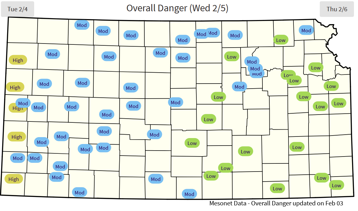
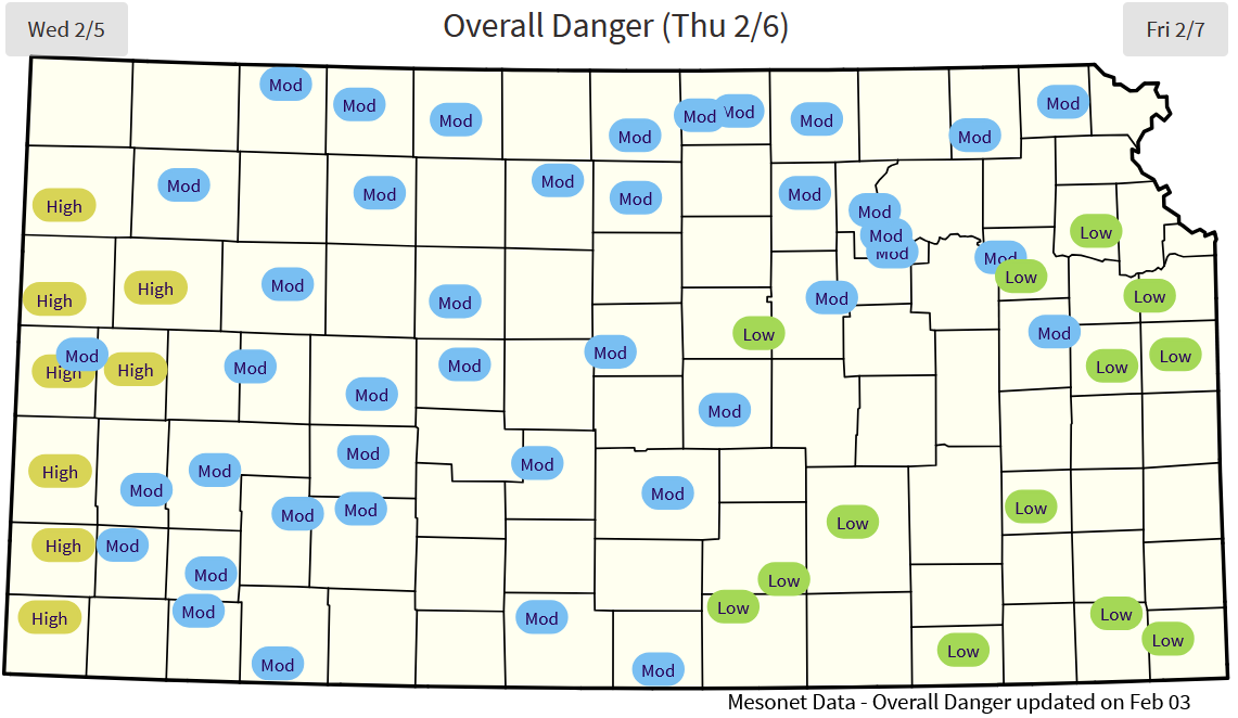
Elevated fire weather Wednesday, February 5th for Stanton to Clark Co and southwestward. Wednesday (5th) - A storm system will push across eastern Kansas with extensive cloud cover, some light precipitation and persistent cool. West of this system in southwest Kansas, much drier southwest flow will push into the state. This will increase winds to 30mph and push afternoon temperatures into the 70F range with afternoon humidity in the 8-13% range. Afternoon conditions will develop elevated fire weather for until the sunsets in the southwest. Overnight recovery will be limited into Thursday for this region with elevated fire weather continuing overnight.
Thursday (6th) - With sunny skies, another cold front sweeps across the state early Thursday with breezy north/northeast winds. Temperatures will be in the mid-40s to 50s with widespread humidity in the 25% range. Slightly drier air expected along the Nebraska border but winds will be lighter in the afternoon. No fire weather expected.
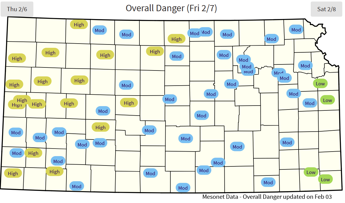
Friday (7th) - Southeast flow returns with moisture and clouds increasing for eastern Kansas. Temperatures will be similar to Thursday but humidity higher, especially for central/east Kansas. Further west, some drier southwest air will try to push into far southwest Kansas in the afternoon. Morton county may see temperatures increase into the 70s with humidity in the teens, however, overall spatial coverage of this potential elevated fire weather is limited. Another cold front crosses the state overnight into Saturday.
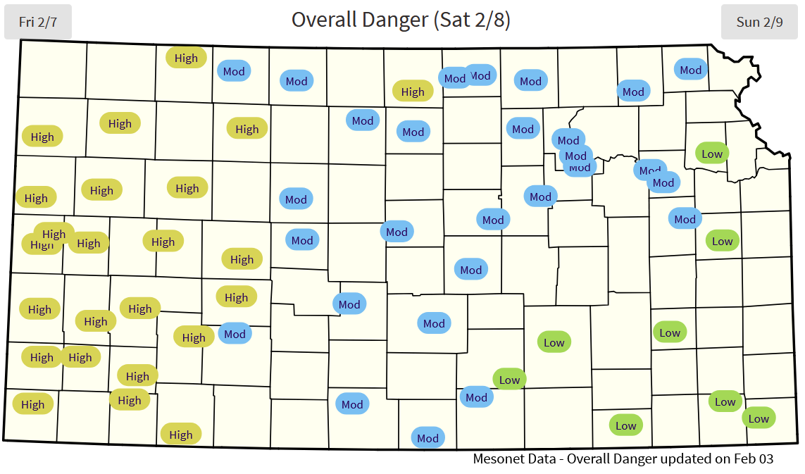
Saturday (8th) - Potent north/northwest winds with gusts to 40+ mph statewide. Afternoon temperatures will struggle to get into the upper 30s. Despite a cooler airmass, drier air and sunny conditions will drop humidity into the 20% range. Some localized elevated fire weather possible, especially where winds are strongest north of I-70.
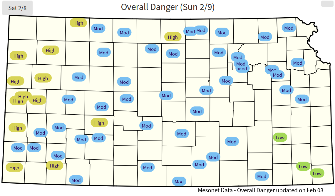
Sunday (9th) - High pressure resides over the region with persistent cooler, dry weather. Afternoon highs will be in the mid-30s with light winds statewide. No fire weather concerns.
Monday (10th) - Southerly flow returns with increasing clouds and moisture despite continued cooler temperatures. No fire weather concerns.
Chip (2/3/25)
Next Update: 2/10/25
| Risk | Humidity | Wind | Other |
|---|---|---|---|
| Elevated | Around 20% | Sustained, greater than 10mph Gusting, greater than 20mph |
Less than Red Flag Warning criteria usually and fire is able to move rapidly |
| Critical | Around 15% | Sustained, greater than 20mph Gusting, greater than 30mph |
Expect Red Flag Warning criteria to be met and very rapid growth likely |
| Extreme | Around 10% | Sustained, greater than 35mph Gusting, greater than 40mph |
Historical fire weather event possible with extreme growth likely |
Please note, forecast is only updated twice weekly unless significant fire risk evolves.